Modeling Applications Collision Investigation and Reconstruction Crime Scene and Criminal Investigations Miscellaneous Studies & Analyses Collision Investigation and Reconstruction We assist
in the investigation of traffic collisions where sun glare or blinding
is suspected as a contributing factor.
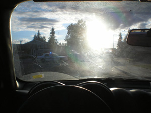
RBA file photo Our model calculates the sun's
position using historical data for any date, time and location,
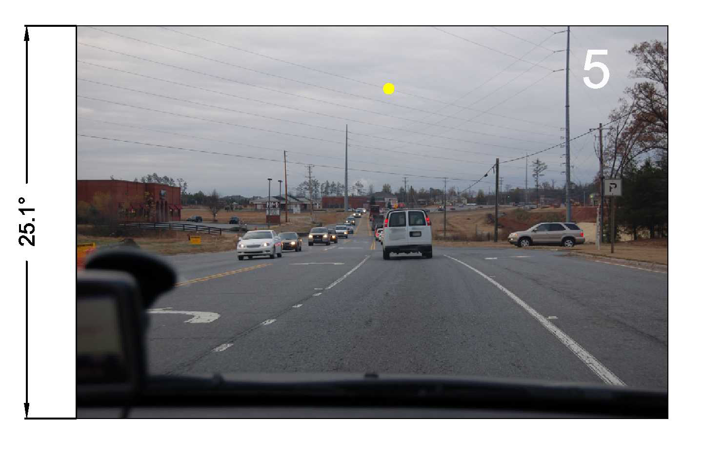
allowing us to prove/disprove witness statements. The picture below is another example of how we can insert the sun into a current photo to demonstrate where it would have appeared at the time of a collision.
Click to Enlarge RBA file photo Collision investigation/reconstruction and legal professionals are encouraged to contact us for free historical sun position data and a free initial consultation. To start, we simply need to know the location, time and date of the incident. (This also applies to those involved in crime scene and criminal investigations - see below.) Crime Scene and Criminal Investigations We assist in the reconstruction
of crime scenes and
in criminal investigations where sun glare or blinding is suspected,
and where there are issues related to visibility / ambient lighting /
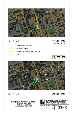
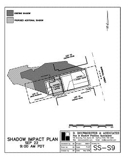
suspect identification. Contact us for free historical sunrise/sunset times, sun position data, and a free initial consultation. We simply need to know the location, time and date of the incident. Many municipalities require shadow impact studies as part of their development approvals process. The drawings and reports which we prepare for our clients (including architects, builders, developers, lawyers, and urban planners) enable them to refine their plans by identifying potential impacts at the preliminary site plan stage. (See "monster home" and "second storey addition" examples.) This streamlines the approvals process and helps avoid costly delays. See feature articles published in the Toronto Star Condo Living section, and in the National Post Post Homes section.
Click to Enlarge graphics by R.
Bouwmeester We also represent property owners and ratepayer groups concerned about the potential shadow impacts of building or development projects proposed in their neighbourhoods. Our modeling techniques provide
an edge to those involved in the marketing of new homes and residential
condominium units. By showing the extent and duration of
sunlight available within specific units or outdoor areas,
potential buyers can
visualize just how sunny they are. We
provide solar data for a variety of unique applications - from simple
sunrise/sunset times for photographers, event and wedding planners,
athletes, coaches and sports teams, marine biologists, medical patients
(e.g. SAD sufferers), TV and radio stations, telephone InfoLines,
operations planners (including the US Air Force in scheduling air
shipments to Antarctica), etc., to sun position charts for film
production planners, photographers, home builders, solar energy
equipment installers, etc. - the
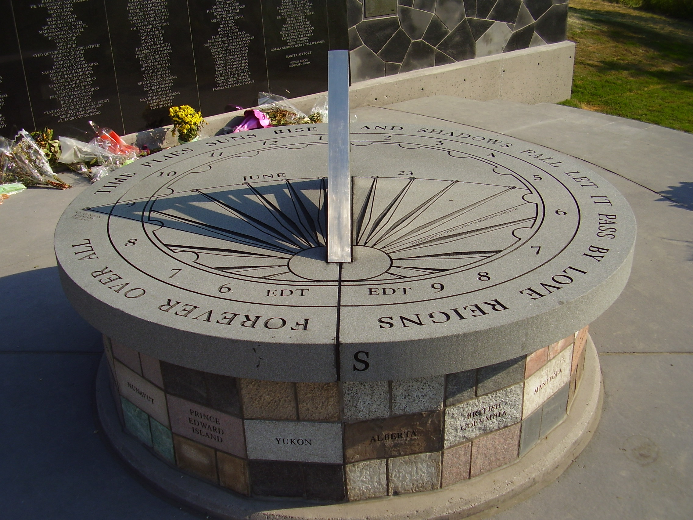
design of a memorial sundial In the Fall of 2006 we were commissioned by the City of Toronto to design a sundial for the Air India Flight 182 Memorial that was to be built in Humber Bay Park East on Toronto's waterfront. The sundial and memorial were unveiled by the Prime Minister of Canada, Stephen Harper, on June 23, 2007, the 22nd anniversary of the Air India Flight 182 bombing. We are honoured to have had our sundial recognized by The North American Sundial Society and registered in their database. A brief write-up and photos can be found on their web site.
Click to Enlarge RBA
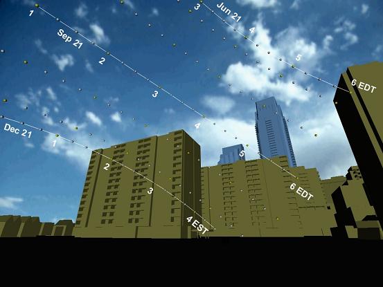
file photo In early 2008 we were retained by BBDO (Toronto) to design a 'solar' billboard for Frito-Lay Sunchips. The billboard, installed in Oakland, California, was unveiled on Earth Day 2008 (April 22) to coincide with the commissioning of Frito- Lay's field of solar collectors that now help power the SunChips plant in nearby Modesto. Quoting the Reuters news agency, "The solar-powered billboard will reveal the SunChips message by casting a shadow changing the look of the outdoor billboard as the sun naturally tracks across the sky". See below for a time-lapse video of the SunChips billboard in action. Ad agency Juniper Park of Toronto took home the 2009 Cassies Grand Prix on January 28, 2010, for the ad campaign that included the billboard. See story. View time-lapse video of our solar billboard by clicking picture below. source: youtube Summary The solar computer model developed by R. Bouwmeester & Associates is a cost-effective and precise tool. Unique solutions are found for sun-related problems in accident and crime scene investigation, urban planning, and building and facility design. Opportunities are capitalized upon, constraints are dealt with, and impacts are mitigated. On projects where time is of the essence, as in the development approvals process, this technological planning and design tool provides clients with a key advantage. With our model we are able to generate sunpath views from any location. In the sample below, one can see at a glance how little sunlight will be lost due to a highrise development proposal (blue buildings). The sun's position (yellow circles) is shown in 15-minute intervals on the 21st of each month from June to December. (December to June will be similar but in reverse - therefore, the entire is represented in this one view.) The loss of sunlight will occur only when the sun passes behind the proposed buildings (e.g. less than 45 minutes on Aug 21, less than 15 minutes on Sep 21 - no new shadows on 21st of Jun, Jul, Oct, Nov and Dec).
graphic by R. Bouwmeester Ralph Bouwmeester, P. Eng.
(Please call or email for complete address details) All the
information contained within these World Wide Web Pages is |
|||||||||||||||||||||||